
Winkler's Sites
Hans Winkler's survey of the northern and central parts of the Central Eastern Desert.
Hans Winkler's survey of the northern and central parts of the Central Eastern Desert.
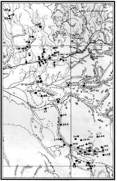
David Rohl notes that without modern maps and gps it would have been much more difficult to relocate Winkler's sites. Winkler used the 1:500,000 maps available in the 1930s which show very little detail outside of the main wadi routes. The dots by which he marked the sites he found are more than a kilometre wide on the ground! Winkler's achievement was considerable. Travelling by camel with a Bedu guide, he recorded systematically in the northern and central wadis. Although Sir Arthur Weigall had travelled along the Wadi Hammamat (and the southern Wadi Kanais), it is Winkler's corpus that all subsequent recorders have built upon. He was the inspiration of the Eastern Desert Survey. Winkler studied and taught at the University of Tubingen until 1933 when he was dismissed by the Nazi authorities because he had briefly been a member of the Communist Party (and had an Armenian wife-Hayastan). In 1932 he had made the same trip as Weigall along the Wadi Hammamat to Quseir, noting the profusion of rock-art there. He adopted the view that has misled a number of commentators since, that the subject of the petroglyphs appeared 'foreign' to ancient Egypt. He subscribed to Petrie's idea that 'Eastern Invaders' probably originating in Mesopotamia came into Egypt via the Red Sea. The petroglyphs, especially those of square-hulled boats, signalled their arrival. In 1934 he surveyed the neighbouring wadis by camel. Failing to gain reinstatement in Germany, he accepted a position with the Robert Mond Expedition. The English industrialist, who used to hand out funds in the form of crispy five pound notes, financed work in both the Eastern and Western Deserts as Winkler later recorded in Gebel Uweinat and the Gilf Kebir, far from the Nile to the West. In November and December 1936 he surveyed the Wadis Hammamat and Qash, including the profusion of petroglyphs at the cave site RME-18. In the early months of 1937 he extended his studies into Wadi Mineh and located RME-26 in the Wadi Abu Wasil, the so-called 'Chieftains' site (see photo on the homepage). Towards the end of the year he did his work in the area of the Gilf Kebir, now the subject of surveying by Andras Zboray. In 1938 the Egypt Exploration Society published Rock Drawings of Upper Egypt in two volumes about the Eastern and Western Deserts. These were preliminary publications and it is probable that Winkler would have returned to this material had not the Second World War intervened. He returned to Germany and was conscripted into the Wermacht. In the First World War Winkler had saved his father's life while they were both serving in the trenches. Winkler's son was arrested by the Gestapo and was never heard of again. Winkler himself was killed near Torun in March 1945. |
| Visitor Counter: | |||||||
 |  |  | |  |  | ||